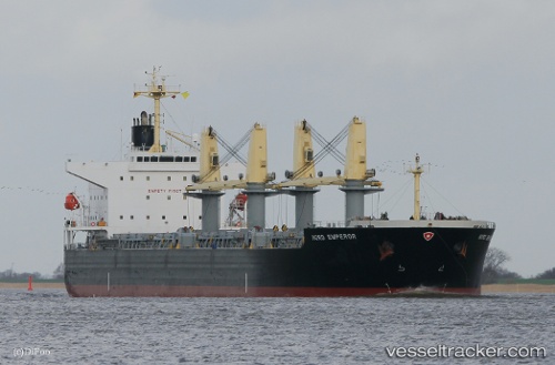
vessel BULK MANARA IMO: 9478951, Bulk Carrier vesseltracker.com
Vessel BULK MANARA IMO: 9478951, Bulk Carrier
MMSI: 636021192 callsign: 5LCS7 size: x

Find the position of the vessel BULK MANARA on the map. The latter are known coordinates and path.

marine traffic ship tracker show on live map

The current position of vessel BULK MANARA is 31.1761 lat / 122.184 lng. Updated: 2025-07-14 16:36:42 UTC

Currently sailing under the flag of Liberia

BULK MANARA built in 2010 year

Deadweight:
55692 t

Details:


Last coordinates of the vessel:
UTC, 31.1188, 122.582, course: 253, speed: 4.5
UTC, 31.1168, 122.486, course: 300, speed: 4.1
UTC, 31.1102, 122.401, course: 247, speed: 10
2025-07-14 16:36:42 UTC, 31.1761, 122.184, course: 305, speed: 11.8

Track of the vessel in the last 14 days


Most frequent ports a vessels calls at BULK MANARA (636021192):

Sambu, traffic: 6
Singapore, traffic: 3
Luderitz Bay, traffic: 3
Paradip, traffic: 2
Chittagong, traffic: 2
Sriracha, traffic: 2
Kandla, traffic: 2
Walvisbaai, traffic: 2
Milner Bay, traffic: 2
Mina Saqr, traffic: 2
Port Hedland, traffic: 1
Selat Sunda, traffic: 1
Dagu Bar, traffic: 1
Dagu, traffic: 1
Ta-Ku, traffic: 1

Link to the map:


Find another ship

BULK_MANARA (636021192) last ports (portcalls and passsages)

Walvisbaai | 2023-12-27 08:25:33
Walvisbaai | 2023-12-23 08:07:19
Luderitz Bay | 2023-12-19 01:19:08
Luderitz Bay | 2023-12-14 23:56:52
Luderitz Bay | 2023-12-10 23:20:02
Sriracha | 2022-12-29 08:35:52
Sriracha | 2022-12-25 08:25:22
Dagu | 2022-09-28 16:46:53
Dagu Bar | 2022-09-28 14:02:18
Milner Bay | 2022-09-13 17:04:47
Milner Bay | 2022-09-09 17:00:39
Manila | 2022-08-31 16:59:23
Selat Sunda | 2022-05-18 19:59:17
Port Headland | 2022-05-12 16:11:03
Singapore | 2022-04-20 03:08:57
Sambu | 2022-04-20 00:36:24
Sambu | 2022-03-31 21:25:07
Sambu | 2022-03-16 03:55:54
Chittagong | 2022-02-28 03:45:02
Kandla | 2022-01-30 04:53:31
Mina Saqr | 2021-12-24 13:32:33
Paradip | 2021-12-01 10:47:37